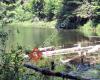
 Pog Lake Campground
2 km
Beautiful campground. Sites are not cramped up together unlike rock lake campground....
Pog Lake Campground
2 km
Beautiful campground. Sites are not cramped up together unlike rock lake campground....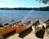 Lake of Two Rivers Campground Office
7 km
If you Google “the best places to camp in Ontario” this place will show up in almost ...
Lake of Two Rivers Campground Office
7 km
If you Google “the best places to camp in Ontario” this place will show up in almost ...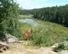 Beaver Pond Trail
7 km
Beaver Pond Trail was our first family walk in Algonquin Park. The weather was very w...
Beaver Pond Trail
7 km
Beaver Pond Trail was our first family walk in Algonquin Park. The weather was very w...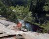 Two Rivers Trail
8 km
A easy trail with great view over the cliff. Though it is called Two Rivers Trail, y...
Two Rivers Trail
8 km
A easy trail with great view over the cliff. Though it is called Two Rivers Trail, y...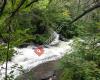 Track and Tower Trail
12 km
Wild, dense and rugged! The hike up to the top offers an incredible view. This trail ...
Track and Tower Trail
12 km
Wild, dense and rugged! The hike up to the top offers an incredible view. This trail ...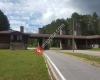 Algonquin Provincial Park - East Gate
12 km
We loved every part of Algonquin. I have been hearing about camping here pretty much ...
Algonquin Provincial Park - East Gate
12 km
We loved every part of Algonquin. I have been hearing about camping here pretty much ...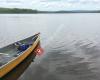 Canisbay Lake Campground Office
14 km
Went here for the first time this weekend and this was also our first ever camping ex...
Canisbay Lake Campground Office
14 km
Went here for the first time this weekend and this was also our first ever camping ex...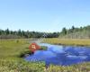 Mizzy Lake Trail
22 km
Definitely a harder trek in the winter. It was beautiful weather for February, sunny ...
Mizzy Lake Trail
22 km
Definitely a harder trek in the winter. It was beautiful weather for February, sunny ...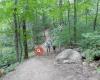 Hardwood Lookout Trail
22 km
1 Km loop with a great lookout right at the end. If you don't follow the signs its on...
Hardwood Lookout Trail
22 km
1 Km loop with a great lookout right at the end. If you don't follow the signs its on... Tea Lake Campground Office
24 km
We had site 34, the week we went the sites next to ours were vacant so that was very ...
Tea Lake Campground Office
24 km
We had site 34, the week we went the sites next to ours were vacant so that was very ...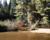 Whiskey Rapids Trail
27 km
It's a nice and short trail. Quite quiet despite the crowds up there.
It's a bit of ...
Whiskey Rapids Trail
27 km
It's a nice and short trail. Quite quiet despite the crowds up there.
It's a bit of ... Algonquin Provincial Park
31 km
Amazing place to relax and enjoy wild life and outdoor activity. Recharge your mental...
Algonquin Provincial Park
31 km
Amazing place to relax and enjoy wild life and outdoor activity. Recharge your mental... Algonquin Provincial Park - West Gate
34 km
What can I say. Fantastic park and we'll maintained. Always a great experience
Algonquin Provincial Park - West Gate
34 km
What can I say. Fantastic park and we'll maintained. Always a great experience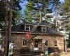 Achray Campground Office
62 km
Beautiful camp ground. The beach is amazing nice sand but lots and lots of zebra muss...
Achray Campground Office
62 km
Beautiful camp ground. The beach is amazing nice sand but lots and lots of zebra muss...to add Centennial Ridges Trail map to your website;