related searches: Cypress falls park west vancouver parking, Cypress falls park west vancouver map, Cypress falls park west vancouver history, Cypress falls park west vancouver hike, Cypress Falls Park West Vancouver reviews, Cypress falls park west vancouver directions, Cypress Falls map, Cypress Falls and Whyte Lake
Ambleside Park
7 km
Very Good beach for families with kids. Sandy and the water is near. Fun Playground. ...
Reviews
A short and easy but still very beautiful trail. The trail could be slippery and tricky when wet. There are some parking lots for about 20-40 cars. We visited this place on a Saturday, in late April and it was not crowded at all. The road to this trail from Vancouver is also very gorgeous.
Beautiful trail and forests! Not very difficult but can be a tad bit slippery. Gorgeous view of the falls. Forest is absolutely beautiful in summer!
Really enjoyed this hike! A bit challenging but not exhausting and we really liked the 2nd waterfall. It didn't feel crowded and the people and dogs along the trail were friendly. Perfect 90-minuteish hike!
We did the Cypress Falls and Whyte Lake hike. It was about 12km and took us 3.5 hours or so. All the waterfalls along the way are beautiful and keeps the hike interesting. There were a lot of tree roots and I wasn’t wearing great shoes so I almost rolled my ankle a couple of times. The lake is a bit underwhelming after all the waterfalls you expect something more.
Nice and easy trail. The day was sunny and I was able to capture good views and the waterfalls. There is part of the trail is slippery but with good shoes you should be ok. There is enough parking but tents to get busy by midday.
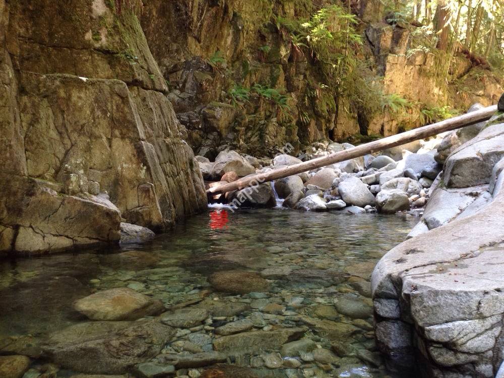
Great easy hike with some giant trees along a beautiful crystal clear creek. The waterfall itself is also worth the hike and if you get inspired there’re a a few places to dip into the water. We loved it! There’re a couple of steep ascents that can be a little challenging for those out of shape, but even our 3 yo was able to walk through… Walking both ways can take 3-4 hours if hiking with small kids. On the way back, there’s the possibility of exiting early and walking on the road.
Loads of bouldering rocks in the forest. Easy hike along the banks of the river to multiple waterfalls. Loops back around over some forest services roads.
Beautiful park. It wasn't terribly busy when we were there which was refreshing for a hike in such a densely populated area. Lower and upper falls. Trails aren't super obvious at times. Watch your footing - can be slippery.
Great trail, while a bit caution is needed for passing cliff edges. Kids should better be at least 3 years old.
Short hike if you go the upper trail, I like the slower way along the creek bed, hopping rocks and climbing over stuff, depending on the water flow, you may have a little bit of swimming, most places you can wade through to keep going till you get to the upper falls


 Altamont Park
3 km
Altamont Park
3 km
 Ambleside Park
7 km
Very Good beach for families with kids. Sandy and the water is near. Fun Playground. ...
Ambleside Park
7 km
Very Good beach for families with kids. Sandy and the water is near. Fun Playground. ...