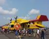
Franklin County State Airport is a public airport located three miles (5 km) west of the central business district of Highgate, a town in Franklin County, Vermont, United States. It is owned by the State of Vermont.Although most U.S. airports use the same three-letter location identifier for the FAA and IATA, Franklin County State Airport is assigned FSO by the FAA but has no designation from the IATA.Facilities and aircraftFranklin County State Airport covers an area of 348acre which contains one asphalt paved runway (1/19) measuring 3,000 x 60 ft (914 x 18 m). For the 12-month period ending August 31, 2009, the airport had 10,200 aircraft operations, an average of 28 per day: 93% general aviation, 7% military and <1% air taxi. There are 86 aircraft based at this airport: 90% single engine, 3% multi-engine, 1% helicopters and 6% ultralights.The airport was purchased by the State of Vermont and a new paved North-South runway was constructed in 1969.For the last 25 years the airport has been known for the odd and unique aircraft based there.
 Greenwoods Airfield
14 km
Northern Lights
17 km
Hawk's Nest
21 km
Odd rules in what could be a very nice venue. Arrived for a table reservation for a b...
Greenwoods Airfield
14 km
Northern Lights
17 km
Hawk's Nest
21 km
Odd rules in what could be a very nice venue. Arrived for a table reservation for a b... Savage Island Airport
29 km
Incredible spot in the middle of Lake Champlain, landing is not allowed unless you ar... Shaw Meadow Airport
34 km
Allenholm Airport
39 km
Savage Island Airport
29 km
Incredible spot in the middle of Lake Champlain, landing is not allowed unless you ar... Shaw Meadow Airport
34 km
Allenholm Airport
39 km
 Plattsburgh International Airport
43 km
On October 30, 2017, I arrived around 10 a.m. for my 11:00 flight to Sanford, Florida... Mountain View Airpark
47 km
Davis Pvt Airport-VT45
48 km
Plattsburgh International Airport
43 km
On October 30, 2017, I arrived around 10 a.m. for my 11:00 flight to Sanford, Florida... Mountain View Airpark
47 km
Davis Pvt Airport-VT45
48 km
 Burlington International Airport
52 km
Worst airport ever. If I could give it a zero trust me I would. First of all, they ...
Burlington International Airport
52 km
Worst airport ever. If I could give it a zero trust me I would. First of all, they ... Douglas Field
57 km
Shelburne Farms Airport
61 km
Frogs End
64 km
Bostwick Farm
64 km
Shelburne Airport-Vt8
65 km
Douglas Field
57 km
Shelburne Farms Airport
61 km
Frogs End
64 km
Bostwick Farm
64 km
Shelburne Airport-Vt8
65 km
to add Franklin County State map to your website;